Tocht Stappen Kenmare Municipal District - Waterville - Staigue - Photo
 luvidine
luvidine

Gebruiker

© OpenStreetMap contributors
Lengte
Lengte
19,9 km
Max. hoogte
Max. hoogte
241 m
Positief hoogteverschil
537 m
Km-Effort
Km-Effort  
27 km
Min. hoogte
Min. hoogte
2 m
Negatief hoogteverschil
490 m
Boucle
Boucle
Neen
Datum van aanmaak :
2014-12-10 00:00:00.0
Laatste wijziging :
2014-12-10 00:00:00.0

(0 Bericht)

Stappen
Stappen
5h44
Moeilijkheid : Medium

Scan deze QR-code om de tocht te openen in de SityTrail-applicatie

Gratisgps-wandelapplicatie

Logo SityTrail SityTrail

IGN / Geografische instituten

SityTrail uit de App Store downloaden SityTrail uit Google Play downloaden

Logo SityTrail SityTrail World

De wereld gaat voor u open

SityTrail uit de App Store downloaden SityTrail uit Google Play downloaden SityTrail op Huawei AppGallery downloaden

Over ons

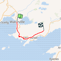
Tocht Stappen van 19,9 km beschikbaar op Onbekend, County Kerry, Kenmare Municipal District. Deze tocht wordt voorgesteld door luvidine.

Hoogteprofiel

Plaatsbepaling

Land:
Ireland
Regio :
Onbekend
Departement/Provincie :
County Kerry
Gemeente :
Kenmare Municipal District
Locatie:
Loughcurrane
Vertrek:(UTM)
419230 ; 5742464 (29U) N.

Wandeltochten in de omgeving

Tocht Andere activiteiten Kenmare Municipal District - Waterville Caherdaniel - Photo
Andere activiteiten
bffcuc

Andere activiteiten

Heel gemakkelijk
Kenmare Municipal District, Onbekend, County Kerry, Ireland
15 km | 20 km-effort
4h 38min
Neen
Tocht Auto Kenmare Municipal District - j03-3 - Photo
Auto
DUPORT16

Auto

Heel gemakkelijk
Kenmare Municipal District, Onbekend, County Kerry, Ireland
78 km | 92 km-effort
3h 3min
Neen
Tocht Stappen Kenmare Municipal District - KW06 - Waterville - Caherdaniel - Photo
Stappen
Tournan

Stappen

Medium
Kenmare Municipal District, Onbekend, County Kerry, Ireland
13,2 km | 17,7 km-effort
3h 48min
Neen


Sluiten
Mijn abonnementen